Nathaniel Lee
Franconia History LLC
HOME
ABOUT
TOURS
SHOP
MAP
CONTACT
MORE
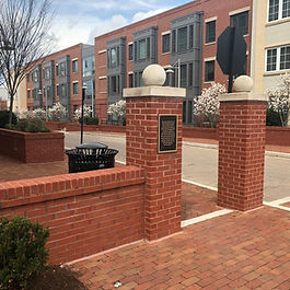
GPS Coordinates: 38.8067762, -77.0624390 Closest Address: 110 Callahan Drive, Alexandria, VA 22301
GPS Coordinates: 38.8068341, -77.0624406 Closest Address: 110 Callahan Drive, Alexandria, VA 22301
GPS Coordinates: 38.8056374, -77.0429029 Closest Address: 313 Cameron Street, Alexandria, VA 22314
GPS Coordinates: 38.8013466, -77.0394823 Closest Address: 3 Pioneer Mill Way, Alexandria, VA 22314
GPS Coordinates: 38.8121701, -77.0512216 Closest Address: 620 North Fayette Street, Alexandria, VA 22314
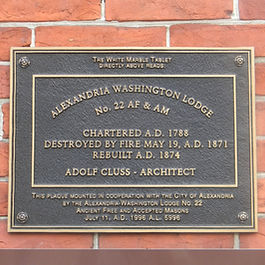
GPS Coordinates: 38.8066935, -77.0623538 Closest Address: 110 Callahan Drive, Alexandria, VA 22314
GPS Coordinates: 38.8060993, -77.0544784 Closest Address: 1325 King Street, Alexandria, VA 22314
GPS Coordinates: 38.7112263, -77.1438454 Closest Address: 202 Belvoir Road, Fort Belvoir, VA 22060
GPS Coordinates: 38.8056696, -77.0431398 Closest Address: 301 King Street, Alexandria, VA 22314
GPS Coordinates: 38.8045820, -77.0397450 Closest Address: 101 North Union Street, Alexandria, VA 22314
GPS Coordinates: 38.8029235, -77.0501239 Closest Address: 301 South Alfred Street, Alexandria, VA 22314
GPS Coordinates: 38.8030013, -77.0498460 Closest Address: 301 South Alfred Street, Alexandria, VA 22314