Colchester Town Archaeological Site
GPS Coordinates: 38.6676228, -77.2364744
Closest Address: 10646 Old Colchester Road, Lorton, VA 22079
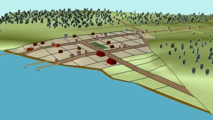
These coordinates mark the site where the colonial town of Colchester stood. Archaeological sites span across what was originally a few city blocks as seen in the picture above.
<•>•<•>•<•>•<•>•<•>•<•>•<•>•<•>
<•>•<•>•<•>•<•>•<•>•<•>•<•>•<•>
Here follows an excerpt from the 1970 Fairfax County Master Inventory of Historic Sites which contained entries from the Historic American Buildings Survey Inventory:
The creation of the town of Colchester on land belonging to Peter Wagener was authorized by an act of the Virginia Assembly in 1753. The reason, as given in the language of the act, was "that a town on Occoquan river ... would be very convenient for trade and navigation, and greatly to the ease and advantage of the frontier inhabitants." In 1754, a survey was made showing a triangular area, with 41 lots and a market place. Purchase of a lot carried the stipulation that the owner must erect, within two years, a house of brick, stone or wood, twenty feet square.
As a port town, Colchester enjoyed a short period of prosperity but was eclipsed by Alexandria and never recovered from a fire which destroyed many of the buildings. By 1820, the town was almost gone. Its significance as an archaeological site stems from the most unusual circumstance that it is still largely in open land, readily available for study.
Colchester is termed a "mixed" archaeological site, because nine of the houses now standing within the original area date from after 1820. In April of 1970, infrared photos of the area were taken by Air Photographics, Inc. J. Glenn Little of Contract Archaeology Inc., provided an interpretation of the film. According to Mr. Little there are nineteen sites within the original town plot. Ten are primary sites showing "potential foundations" which require fieldwork for further identification. The others are secondary sites represented by a visual disturbance on the film, but the clarity of color and degree of reflectivity of the surrounding soil, as shown in the infrared photo, was insufficient to determine measurements, though enough to determine shape. Three roads were identified, one of which may represent the street parallel to the present Colchester Road.
It is expected that investigation currently underway will provide more information about the old town of Colchester.